Last spring when COVID first emerged I created a geocaching course out at Termination Point for our April training as a safe way for members to do something SAR-adjacent when we could not get together for a normal training. I have obtained workers comp insurance again for KISAR members from now until December 20 to repeat this training. If anyone did not have an opportunity in the spring to run the course, or if you did it in the spring and would like to do it again, this will serve as our December training topic.
The purpose of this training is to practice navigation with the Gaia GPS app (https://www.gaiagps.com/ or another gps phone app of your choice). Below I will provide the latitude and longitude for 11 Navy Seal course orienteering points. Some reside in parts of the Termination Point forest that very few people visit.
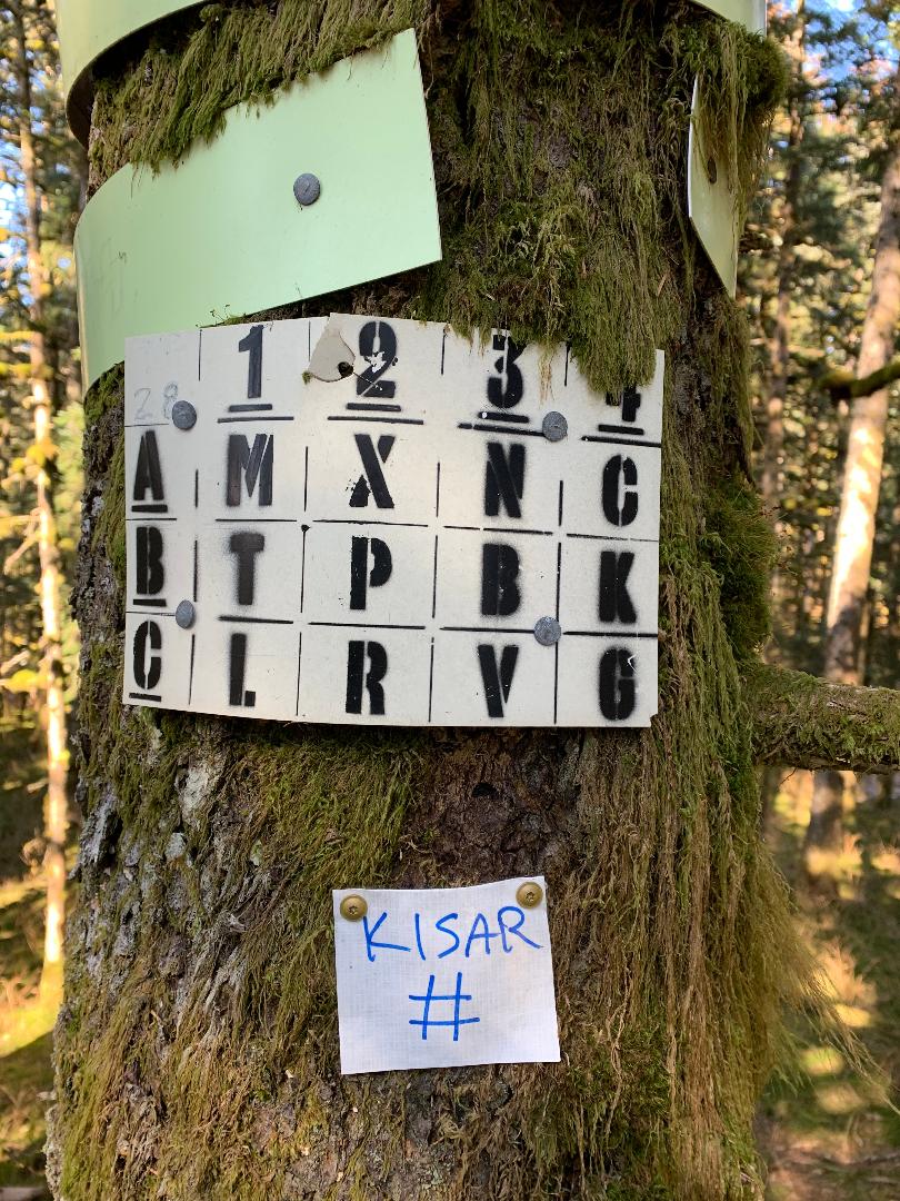
At each of the 11 locations you will find a small Tyvek sign with “KISAR” in blue permanent marker, below which there will be either a letter or number (see the attached example; the # will be replaced with an alpha-numeric character). You will need to record this letter or number from each location. After locating all 11 symbols, arrange them to form a common phrase (yes, it is a puzzle, but this shouldn’t be too challenging). After you complete these tasks let me know directly via an email (don’t reply to kisar emails which go to everyone). Every KISAR member who completes this training by December 20 wins a sew-on KISAR patch (yay, prizes!).
On this course you may encounter swamps, devil’s club and salmonberry patches, dense forest and windfall depending on how you navigate. I know the area well and it took me over 2.5 hours and I traveled 6 miles to complete it. You should assume it will take you longer, so do NOT wait until the afternoon to get started. I HIGHLY recommend you record your track in Gaia because it forces your phone to update your location constantly. If you don’t record, your phone may take a long time to acquire your location again in the dense trees. If you need to bone up on your Gaia GPS app skills, this is a short but very comprehensive tutorial: https://youtu.be/KhZlQuvX-Uc.
In order to enter the required waypoints, you will need to be able to do is create a new waypoint, and then change the latitude and longitude values to move that waypoint to the correct location. You can enter these at home before heading out. Here are the 11 geocache locations:
- 57.84131, -152.42726
- 57.84168, -152.42127
- 57.84677, -152.41010
- 57.84824, -152.41483
- 57.85127, -152.42423
- 57.86077, -152.43079
- 57.86126, -152.43293
- 57.86121, -152.42729
- 57.86089, -152.42525
- 57.85168, -152.42930
- 57.84811, -152.42653
Please note that the free version of Gaia does not offer the use of cached maps for offline use, and part of this course does not have cell coverage. Keep that in mind before you head out. Gaia is an excellent app and essential for the work we do. Consider getting the basic paid version. I am working on getting a KISAR team discount through Gaia.
Treat this like a real training and bring a well-provisioned pack with communication resources like an inReach (at least half the course has no cell coverage) and a phone battery backup, food & water, clothing, first aid & safety gear, and maybe even a light shelter and stove. Microspikes (or similar) are suggested and I highly recommend trekking poles. There could be bears around so take the normal precautions like make noise and carry bear spray. For safety reasons I recommend doing this in pairs so if there is someone you feel safe going with (you have been in quarantine with them) proceed as normal. If you go with another person that you have not been in quarantine with, please drive out in separate cars and travel together but stay appropriately physically distanced during the day. If someone really wants to do this training but can’t find a partner, send Philip an email and I would be happy to tag along. If you have any questions, don’t hesitate to email Philip.
Please let the KISAR board of directors know that you are headed out and send us another email after you return so we know who is out there. Have fun and be safe!