
For our May training I have set up another geocaching course, this time on Near Island. For folks who know all the smaller social trails the hiking part of this will be easy. If you aren’t familiar with the lesser traveled tracks, this will introduce you some of them. When I walked it recently it was less than 3 miles and it took less than 1.5 hours.
Rather than enter all the waypoints before entering the course, I am only providing the starting waypoint (57.78688, -152.39272). Once you find it, the next waypoint will be written on the Tyvek tag at that location. Each waypoint tag will give you the location of the next one. The main object of this exercise is to learn how to switch between coordinate systems in Gaia when entering waypoint data. We will be using all 5 of Gaia’s available coordinate systems. You can switch between coordinate systems under Settings > Units > Coordinate Type… The options are:
Decimal degrees (D.d)
Degrees and decimal minutes (Dm.m)
Degrees, minutes, and seconds (Dms)
Universal Transverse Mercator (UTM)
Military Grid Reference System (MGRS)
Most of us are familiar with geodetic polar coordinate systems like latitude and longitude, but some of us may not have spent much time using UTM or MGRS. Both are based on the same metric square grid overlay of the surface of the earth and only differ in their notation. An explanation of how UTM and MGRS grids are generated and what the values mean is outside the scope of this particular exercise, but if you want to geek out on the subject this video is pretty comprehensive for explaining UTM: https://youtu.be/qstBRB8Og18. This website offers some cool coordinate conversion tools: http://www.earthpoint.us/Convert.aspx.
The Tyvek tag you will be encountering at each waypoint will look something like this:
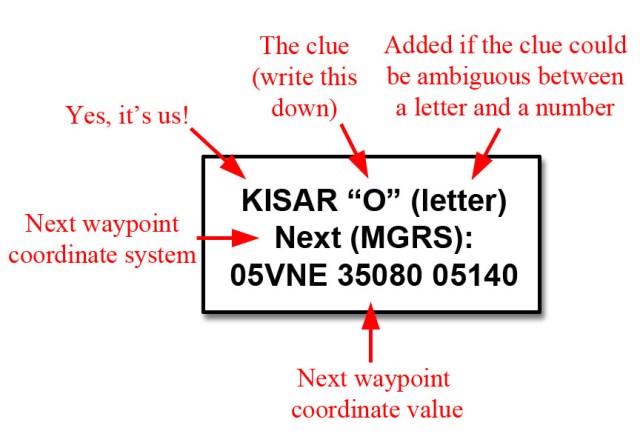
You will want to document the letter or number inside the quotation marks for each waypoint. Like the last training you will need to decipher what phrase they create once you have them all, and then navigate to the location indicated and note what you see there (an additional step). Email the results to tscheezy @ yahoo DOT com when you are finished. If you want to practice entering a coordinate in Gaia, use the MGRS value in the example tag. Switch to the necessary coordinate unit in the settings first, then return to the map and drop your waypoint and enter the values. It should put you in the small boat harbor downtown.
Again, the starting location for this course in decimal degrees (D.d) is: 57.78688, -152.39272
Please send an email to Steve Wielebski, Nick Szabo, and Mike Gibbs so we can keep track of who is doing the course. Near Island is a safe place, but we need to document who participates in these trainings for insurance coverage and to let the Troopers know we still exist.
Steve: orionssports AT yahoo DOT com
Nick: kisar1986 AT gmail DOT com
Mike: gibbsm24 AT hotmail DOT com